- Startseite
-
About us
-
Crisis Information
- Crisis Information
- Overview
- Mapping and Exercises
- Monitoring Services
-
Services and Projects
-
Latest
- EnglishDeutsch
- Accessibility
- Press
>
Crisis Information>
Mapping and Exercises>
Tropical Cyclone Phet - Flash flood along the Sindh Coast of Karachi
Startseite
>
Crisis Information>
Mapping and Exercises>
Tropical Cyclone Phet - Flash flood along the Sindh Coast of Karachi
Tropical Cyclone Phet - Flash flood along the Sindh Coast of Karachi
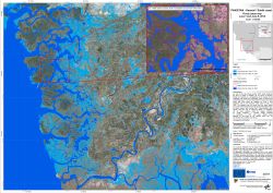
undefinedOn June 6, 2010 the tropical cyclone Phet made landfall at the town of Thatta in Pakistan, 50 km South of Karachi. Strong rain intensity as a consequence of the cyclone led to collapsing mud houses and submerging roads in Karachi and surrounding areas. ZKI provides Flood Maps for the World Food Programme in the framework of the GMES Emergency Response project SAFER with funding from the European Community's Seventh Framework Programme.
Products
Pakistan - Karachi - P01 - Satellite map of the flooded area based on Cosmo-SkyMed imagery acquired on June 7 and 9, 2010 - Overview
Creation Date 11. June 2010
Further links
undefined


