- Startseite
-
About us
-
Crisis Information
- Crisis Information
- Overview
- Mapping and Exercises
- Monitoring Services
-
Services and Projects
-
Latest
- EnglishDeutsch
- Accessibility
- Press
>
Crisis Information>
Mapping and Exercises>
Floods on the River Neisse (border triangle Czech Republic-Poland-Germany)
Startseite
>
Crisis Information>
Mapping and Exercises>
Floods on the River Neisse (border triangle Czech Republic-Poland-Germany)
Floods on the River Neisse (border triangle Czech Republic-Poland-Germany)
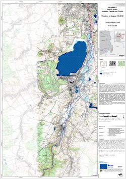
undefinedBeginning of August 2010 heavy rains in Central Europe caused floods in the border triangle of Czech Republic, Poland and Germany. Although a lot of effort was put in evacuating people, several persons died due to the inundations and severe damages to households and infrastructure were reported. The most affected region on German territory was the Free State of Saxony, which had to fight against very fast rising water levels. Therefore, in many Saxon districts emergency alert was triggered. ZKI provides Reference and Flood Maps in the framework of the GMES Emergency Response project SAFER with funding from the European Community's Seventh Framework Programme.
Products
Germany - River Neisse between Ostritz and Goerlitz - P01 - Flood as of August 10, 2010 - Disaster Extent Map - Detail
Creation Date 11. August 2010
Further links
undefined


