15. July 2021

Storms and heavy rain cause floods in Western Germany

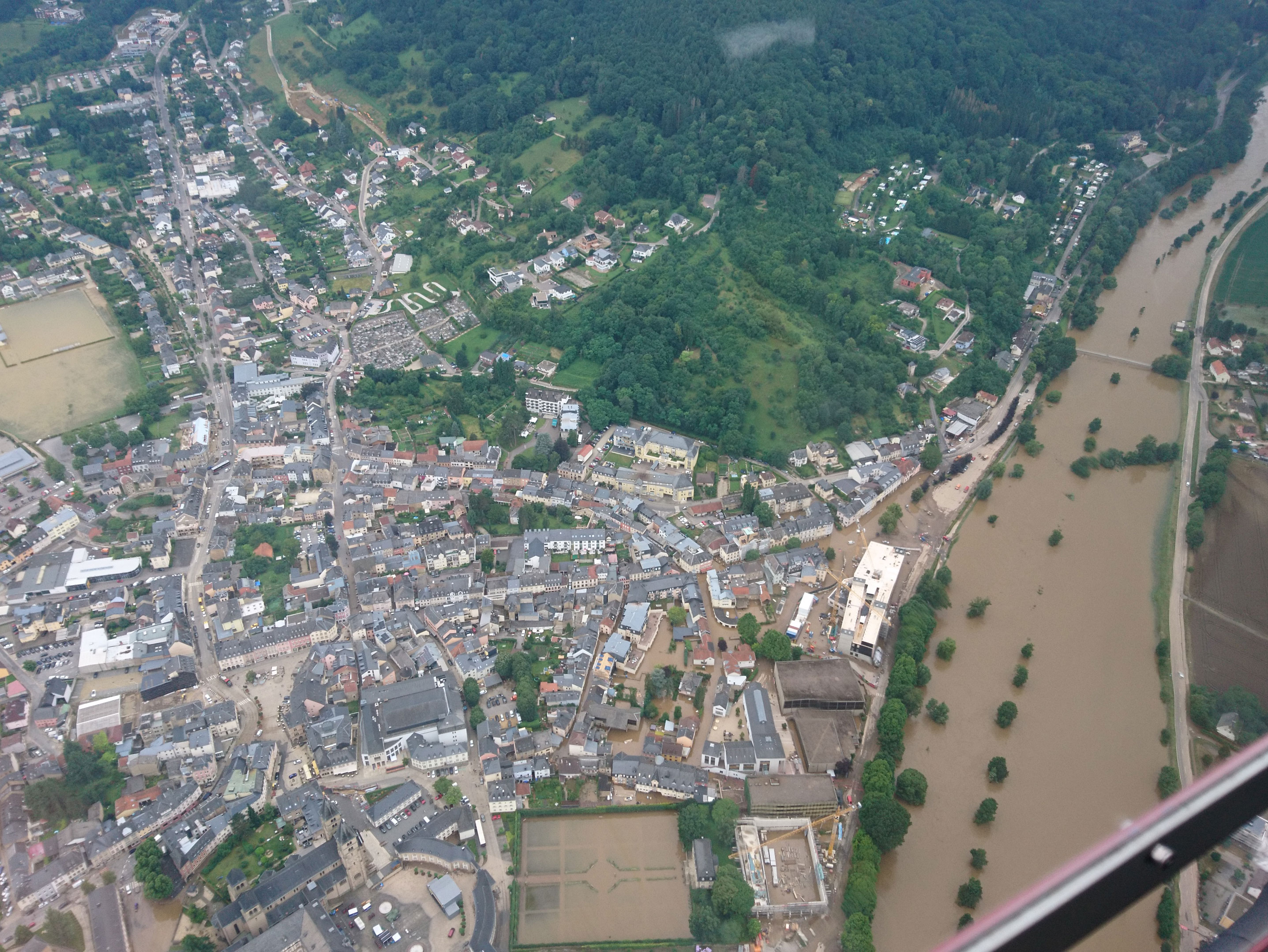
Echternach at the river Sauer on 16.07.2021 (helicopter view).
Credit:
@DLR 2021
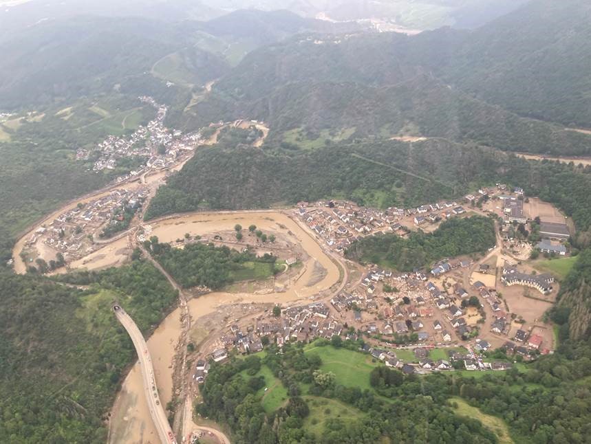
Destroyed villages and infrastructure (helicopter view on 16.07.2021).
Credit:
@DLR 2021
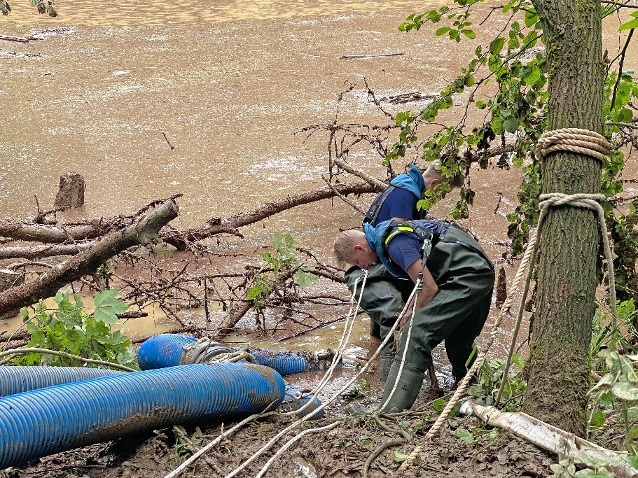
THW employee during the current storm.
Credit:
©THW

In western Germany, prolonged heavy rain caused numerous floods. People lost their lives, numerous buildings and infrastructures were destroyed. Places in North Rhine-Westphalia and Rhineland-Palatinate are particularly affected. ZKI is supporting the emergency and rescue teams with a range of activities: satellite data and DLR aerial photographs are evaluated within a very short time and processed into maps, for example.

The ZKI passes on the situation information to the Federal Office of Civil Protection and Disaster Assistance (BBK). Official emergency forces are welcome to contact GKT(at)bbk.bund.de for access.

The ZKI has derived flood information for regions in western Germany from satellite data (Sentinel-1) using automated procedures. The generated water masks, which illustrate the extent of the water areas, are available for download below. In addition, the ZKI shows particularly affected regions, which were defined together with the local rescue forces, in up-to-date situation maps. For this purpose, DLR aerial imagery with resolutions of ten to 15 centimetres were captured with a camera from the Remote Sensing Technology Institute (IMF). The flights were spontaneously realised in cooperation with partners.

For situational awareness in the disaster area, DLR's own developments of the Remote Sensing Technology Institute (IMF) '3K camera' on the DO 228 aircraft and its successor, the '4k camera system' on an EC 135 helicopter were used as aerial cameras. These are 3-head camera systems which, thanks to the combined nadir and side-view arrangement of the cameras, can image a large area perpendicular to the direction of flight and thus cover large-area target areas even at high resolution with only a few passes. The 4k camera system also offers in-flight processing of aerial image data through its built-in onboard computer unit. In this process, georeferenced and orthorectified aerial images are calculated directly in the helicopter from the captured images, which are then immediately processed into map products by ZKI on the ground. In the future, these pre-processed aerial images will be transmitted to the ground in real time via LTE in order to provide rescue and emergency forces with up-to-date situation maps at all times. The aerial survey with the DO 228 was carried out by DLR Flugbetrieb. The helicopter was provided by Helicopter Travel Munich GmbH.

The images and maps are produced as part of the AIFER research project in close cooperation with the Bavarian Red Cross (BRK) and the German Red Cross (DRK). AIFER develops artificial intelligence (AI) methods that automatically recognise and fuse information from satellite data, aerial images and media. The Federal Ministry of Education and Research (BMBF) is funding the project.

On July 20, the flooded areas in Rhineland-Palatinate, including the entire Ahr valley from Müsch to the mouth in Sinzig, were again photographed by DLR. The aerial camera system MACS (Modular Aerial Camera System) from the Institute for Optical Sensor Systems in Berlin was used. It is equipped with several sensors in the visible and near-infrared spectral range, allows flexible recording configurations and delivers high-resolution image data even under difficult lighting conditions. The integrated data processing unit generates georeferenced images in real time, which are directly processed into different geodata products after landing.

The aerial survey was carried out spontaneously at the request of the BBK. The company BSF provided an airplane (Cessna 206), in which MACS was installed within one hour. As a result of the aerial survey, extensive maps of the flooded areas were created, which will be integrated into the information systems of the ZKI and BBK.

The flight was carried out within the framework of the Helmholtz Innovation Lab OPTSAL, whose goal is to transfer optical technologies for situational awareness into operational applications.

Products

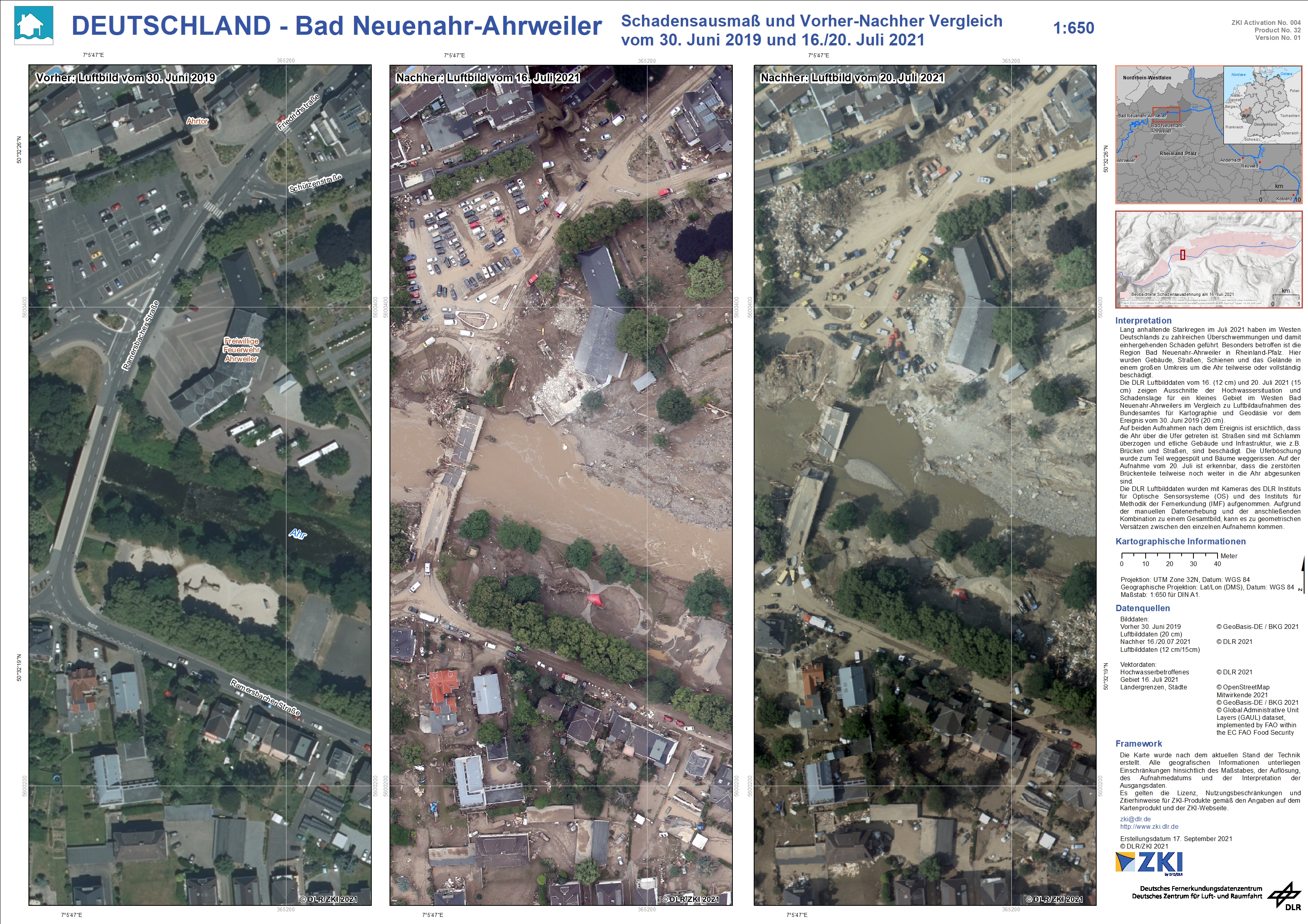
Germany – Bad Neuenahr-Ahrweiler – Flood – P32 – Extent of damage and before and after comparison as of 30th of June and 16th/20th July

Creation Date 17. September 2021

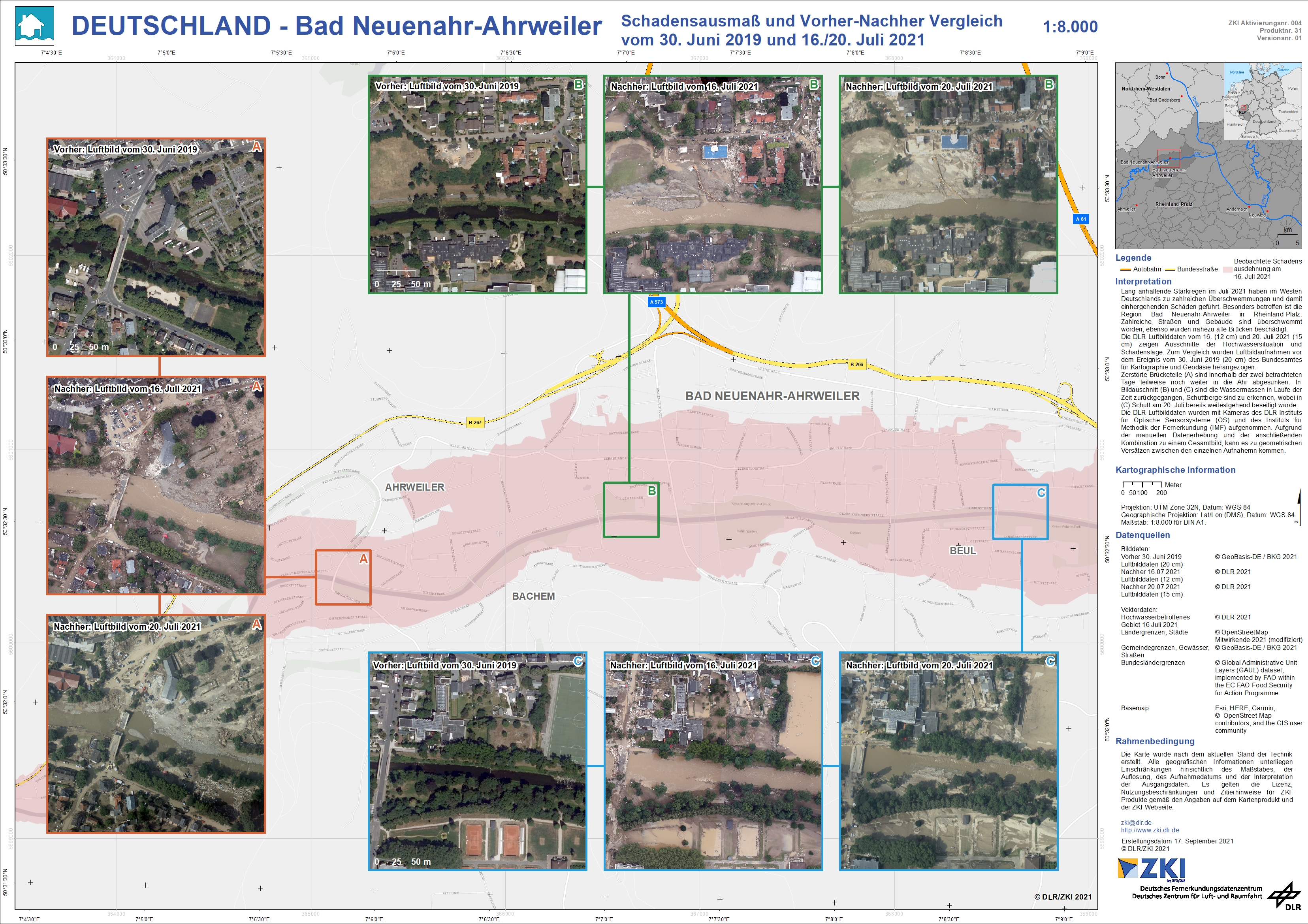
Germany – Bad Neuenahr-Ahrweiler – Flood – P31 – Extent of damage and before and after comparison as of 30th of June and 16th/20th July, for three areas

Creation Date 17. September 2021

Germany – Erftstadt/Blessem – Flood – P30 – Extent of damage and before and after comparison as of 30th of June and 16th/18th July

Creation Date 17. September 2021

Germany – Rheinland-Pfalz / Nordrhein-Westfalen – Flood – P29 – Automatically detected damage extent on July 16th 2021

Creation Date 13. September 2021

Germany – Ahr – Flood – P28 – Manually detected damage extent on July 16th 2021

Creation Date 10. September 2021

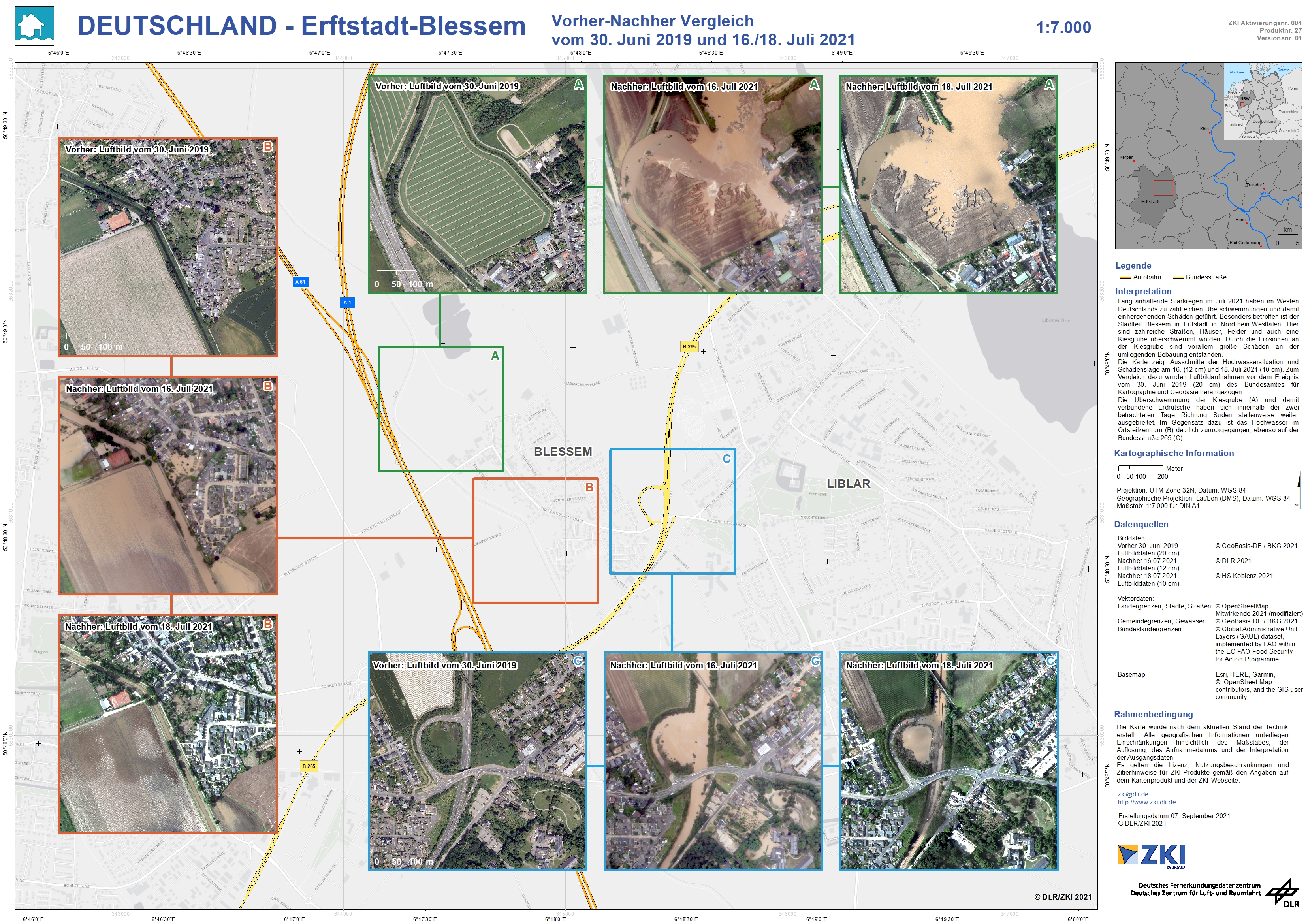
Germany – Erftstadt/Blessem – Flood – P27 – Before and after as of 30th of June and 16th/20th July

Creation Date 09. September 2021

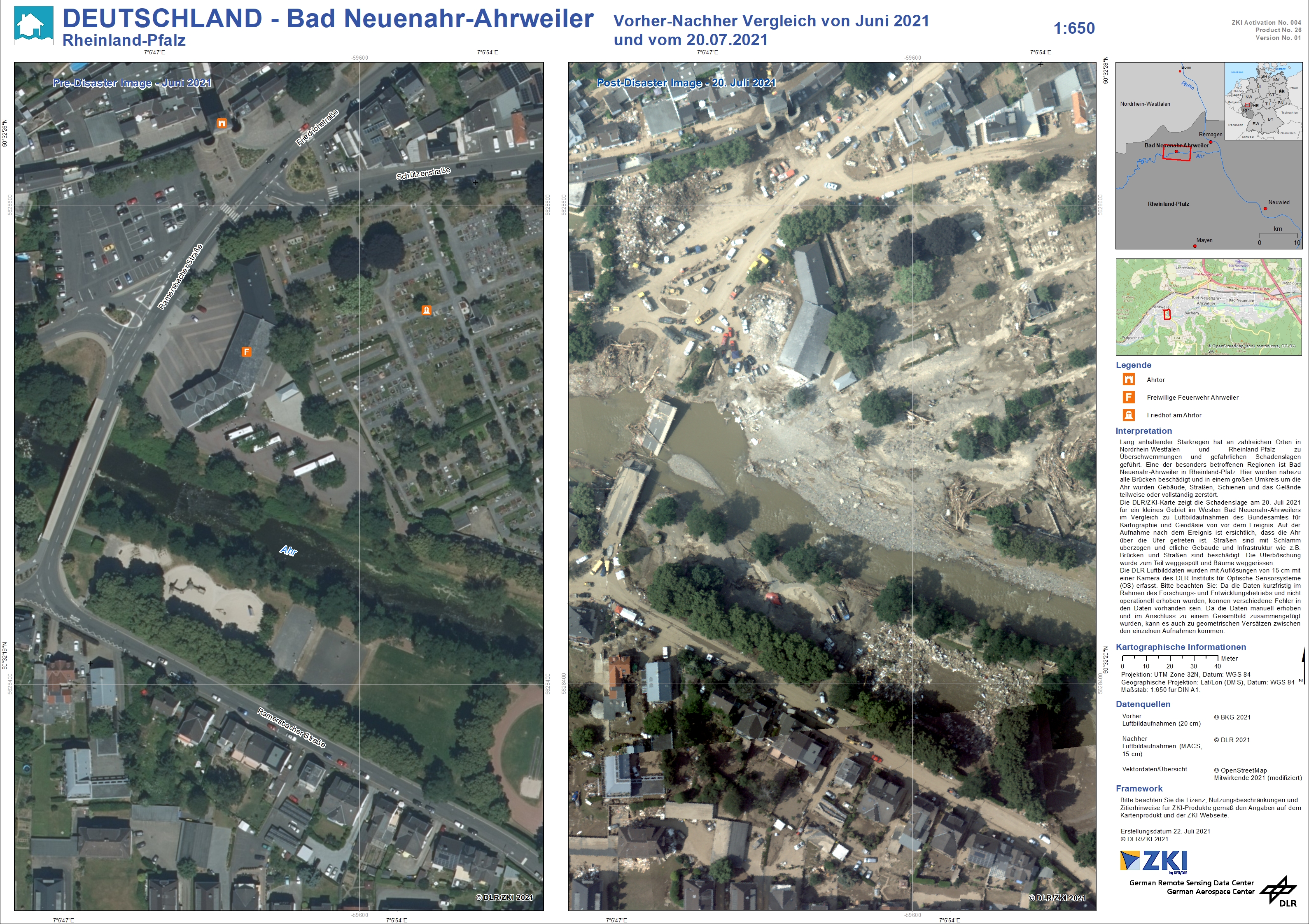
Germany – Bad Neuenahr-Ahrweiler – Flood – P26 – Before and after as of 20 July 2021

Creation Date 22. July 2021

Germany – North Rhine-Westphalia – Flood – P17 – Flood Masks from 19 Juli 2021, Sentinel-1

Creation Date 20. July 2021

Germany – North Rhine-Westphalia – Flood – P16 – Flood Masks from 18 Juli 2021, Sentinel-1

Creation Date 20. July 2021

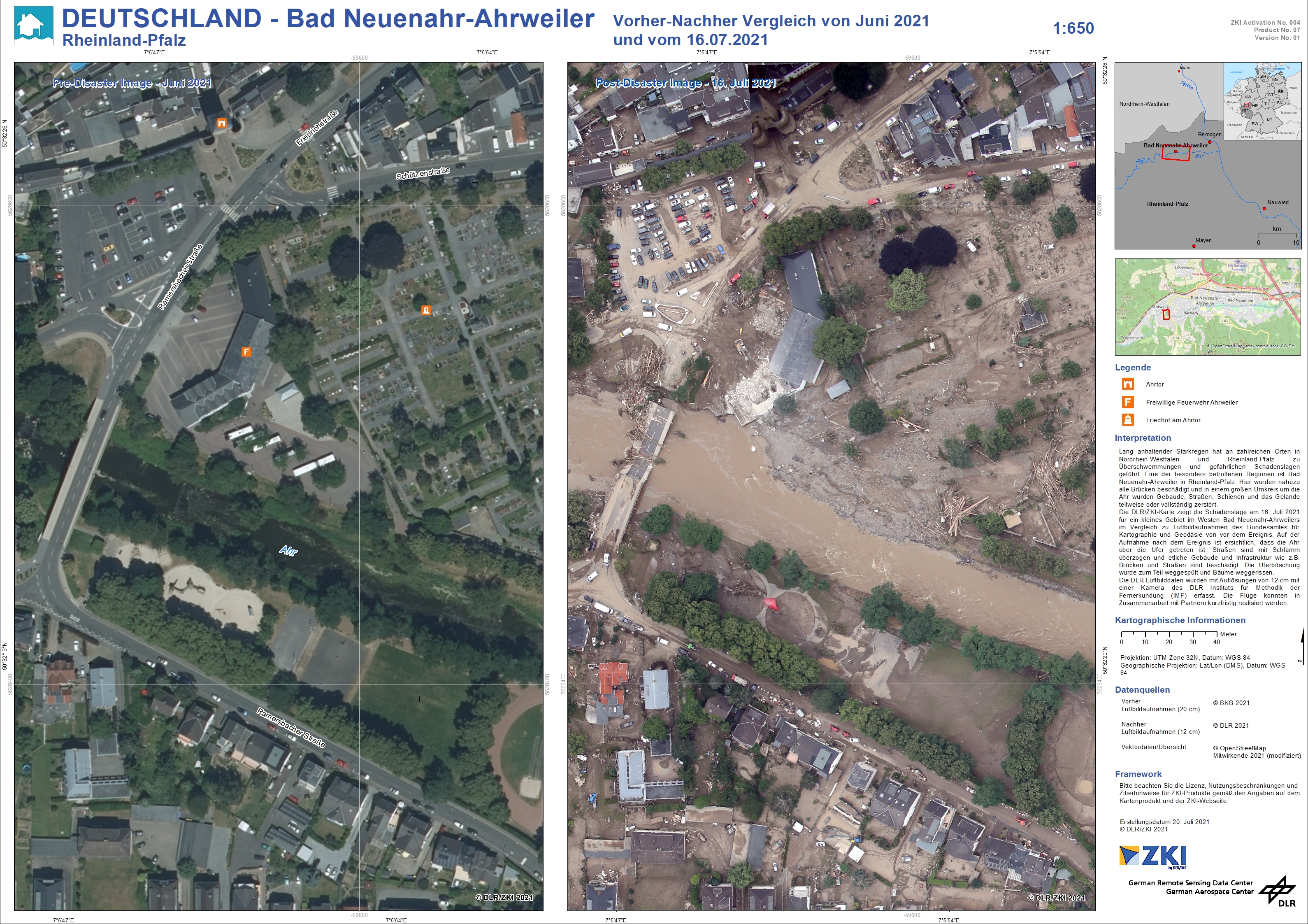
Germany – Bad Neuenahr-Ahrweiler – Flood – P07 – Before and after as of 16 July 2021

Creation Date 20. July 2021

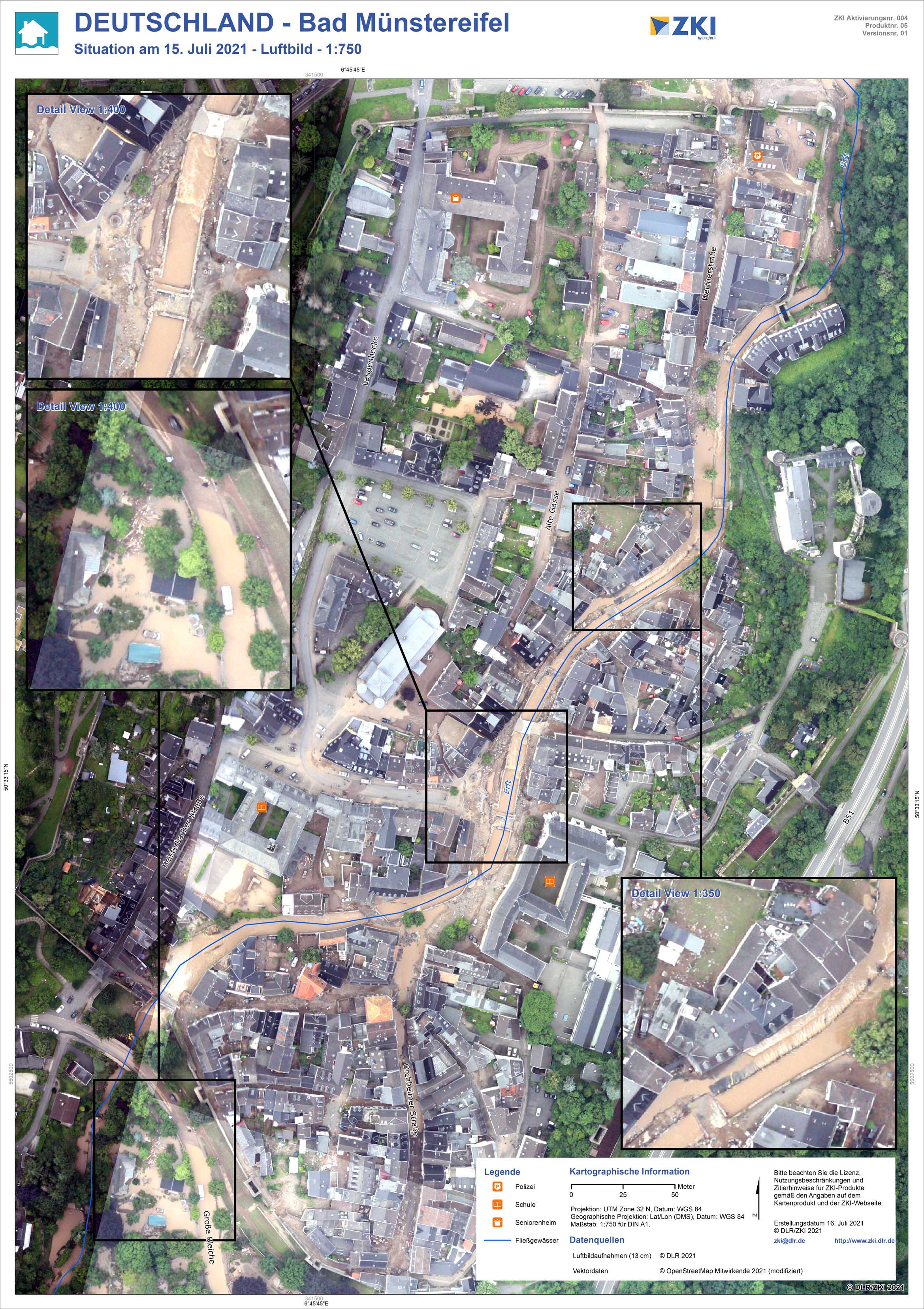
Germany – District Bad Muenstereifel – Flood – P05 – Aerial map of the floods as of 15 Juli 2021

Creation Date 16. July 2021

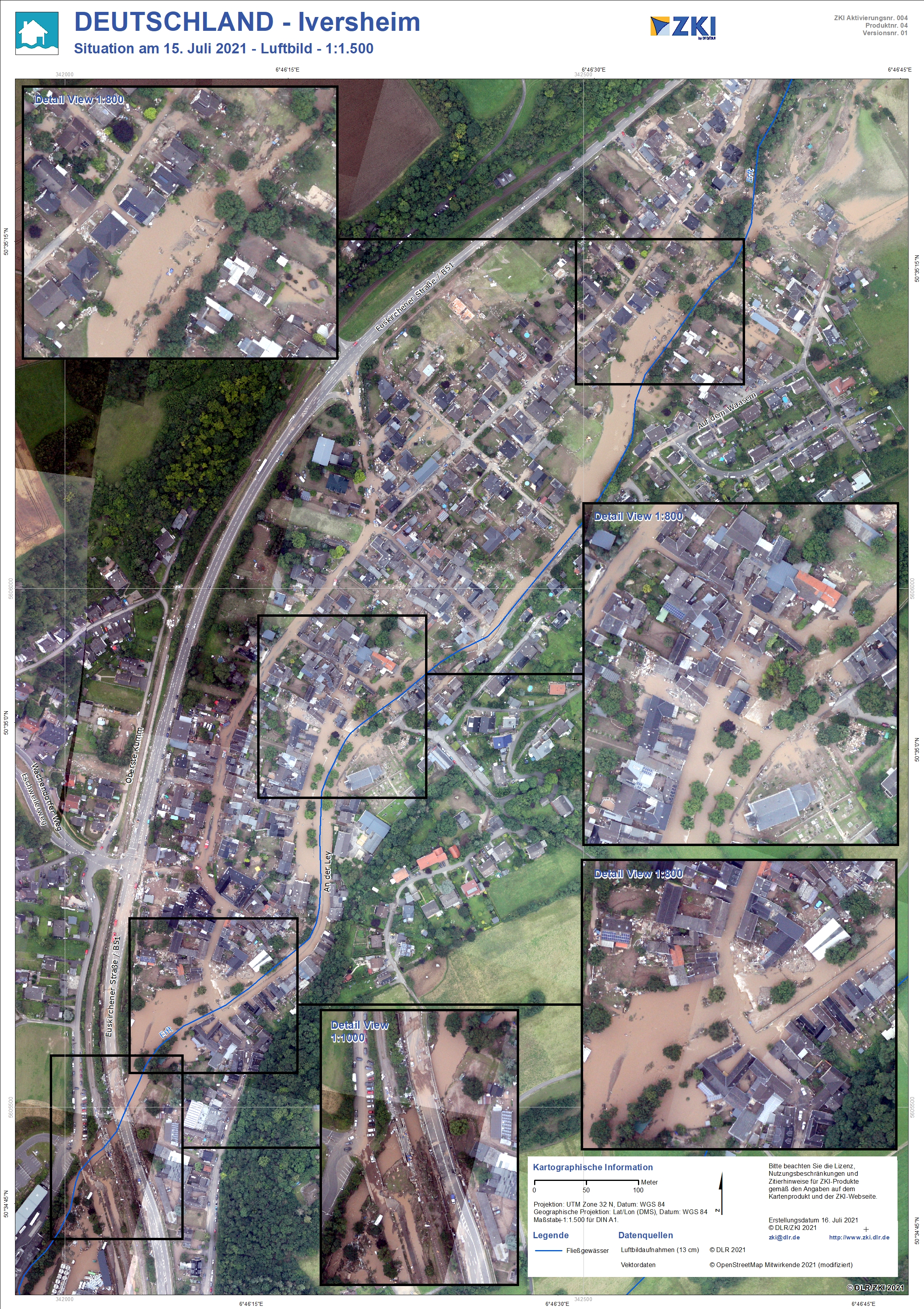
Germany – District Iversheim – Flood – P04 – Aerial map of the floods as of 15 Juli 2021

Creation Date 16. July 2021

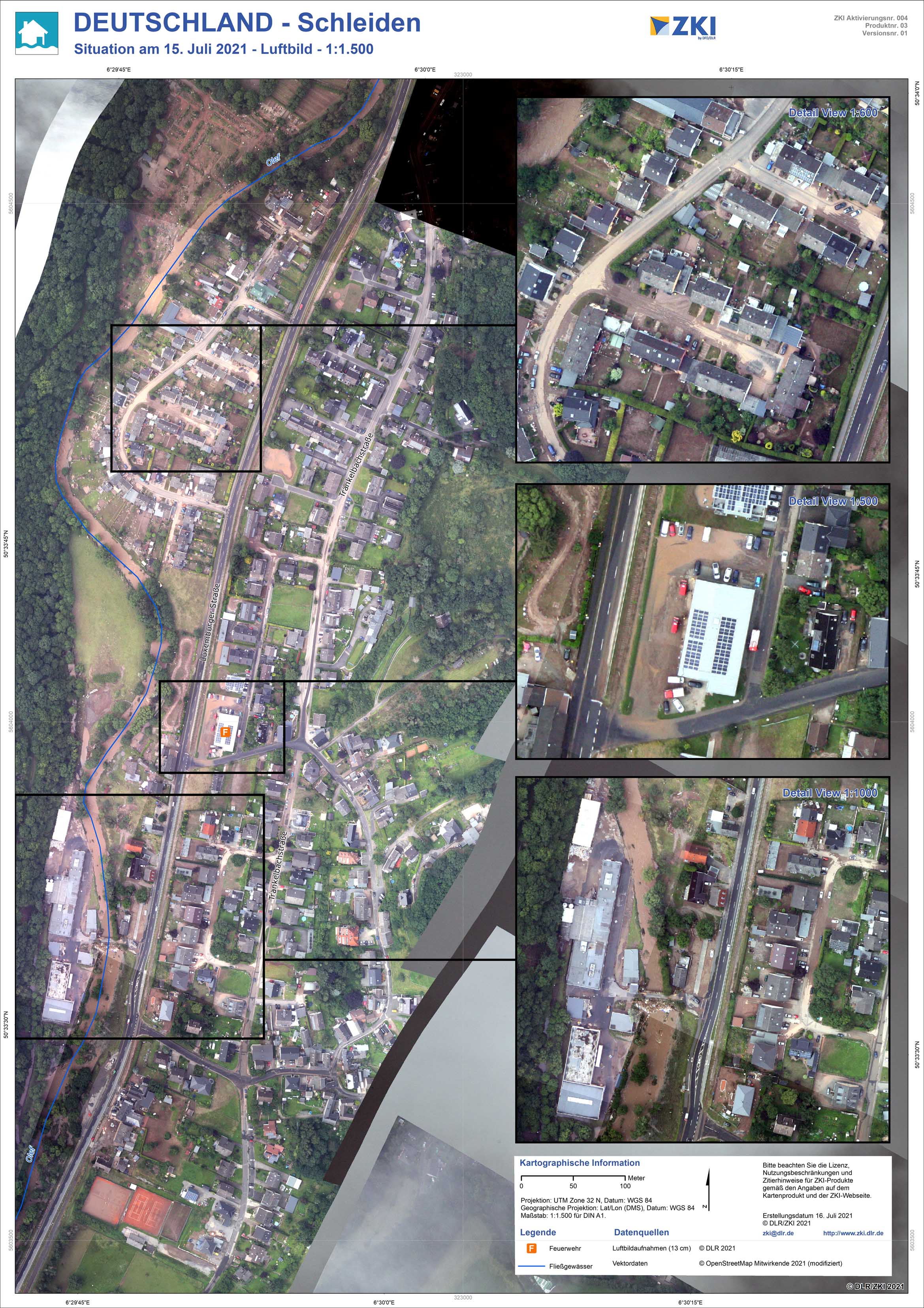
Germany – District Schleiden – Flood – P03 – Aerial map of the floods as of 15 Juli 2021

Creation Date 16. July 2021

Germany – North Rhine-Westphalia – Flood – P06 – Flood Masks from 16 Juli 2021, Sentinel-1

Creation Date 16. July 2021

Germany – North Rhine-Westphalia – Flood – P02 – Flood Masks from 15 Juli 2021, Sentinel-1

Creation Date 15. July 2021

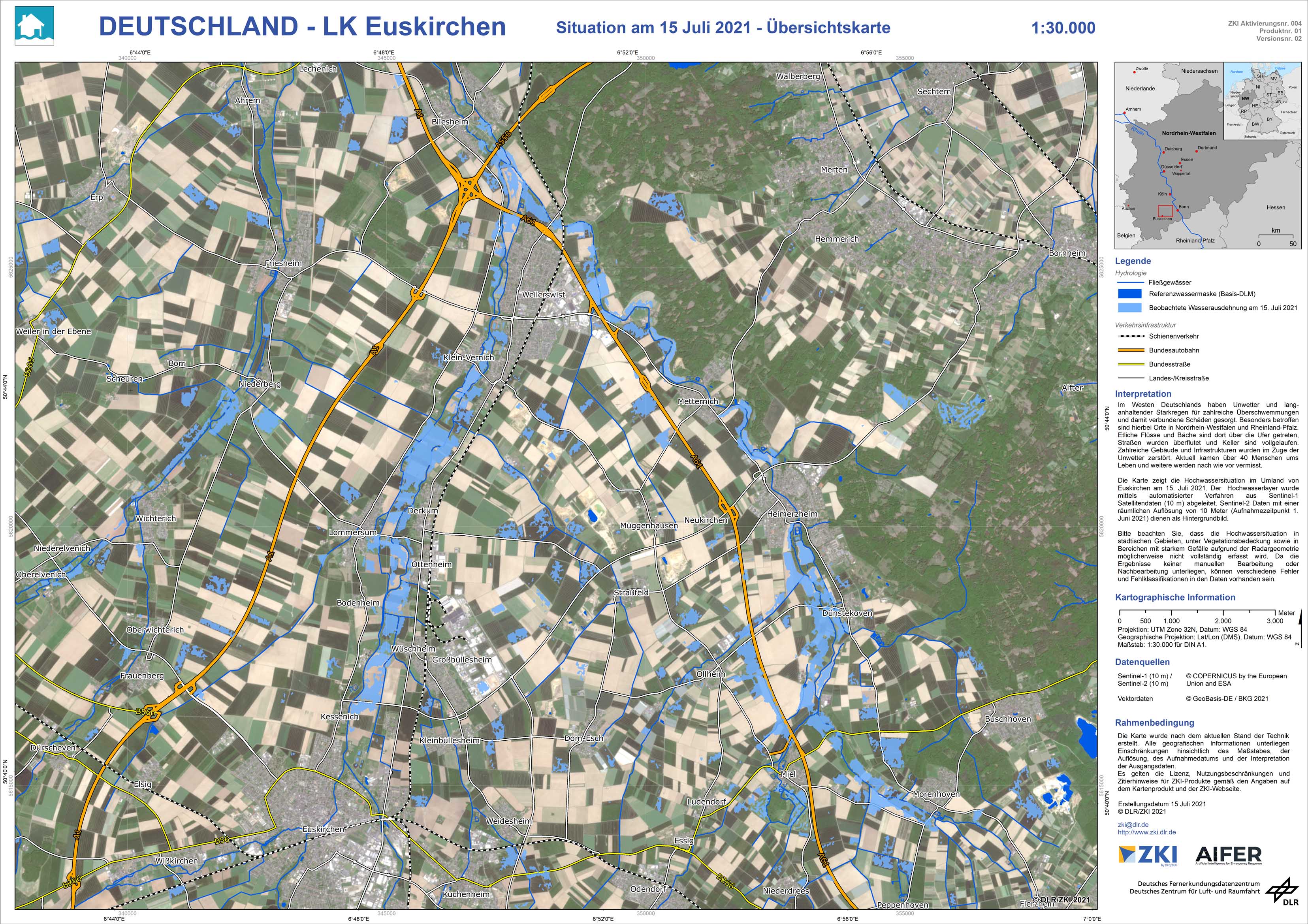
Germany – District Euskirchen – Flood – P01-V02 – Updated Situation Maps of the floods as of 15 Juli 2021

Creation Date 15. July 2021