Forest Fires Around the Mediterranean Sea: ZKI Supports with Information on the Development of Fire Areas
01. August 2023
Forest Fires Around the Mediterranean Sea: ZKI Supports with Information on the Development of Fire Areas
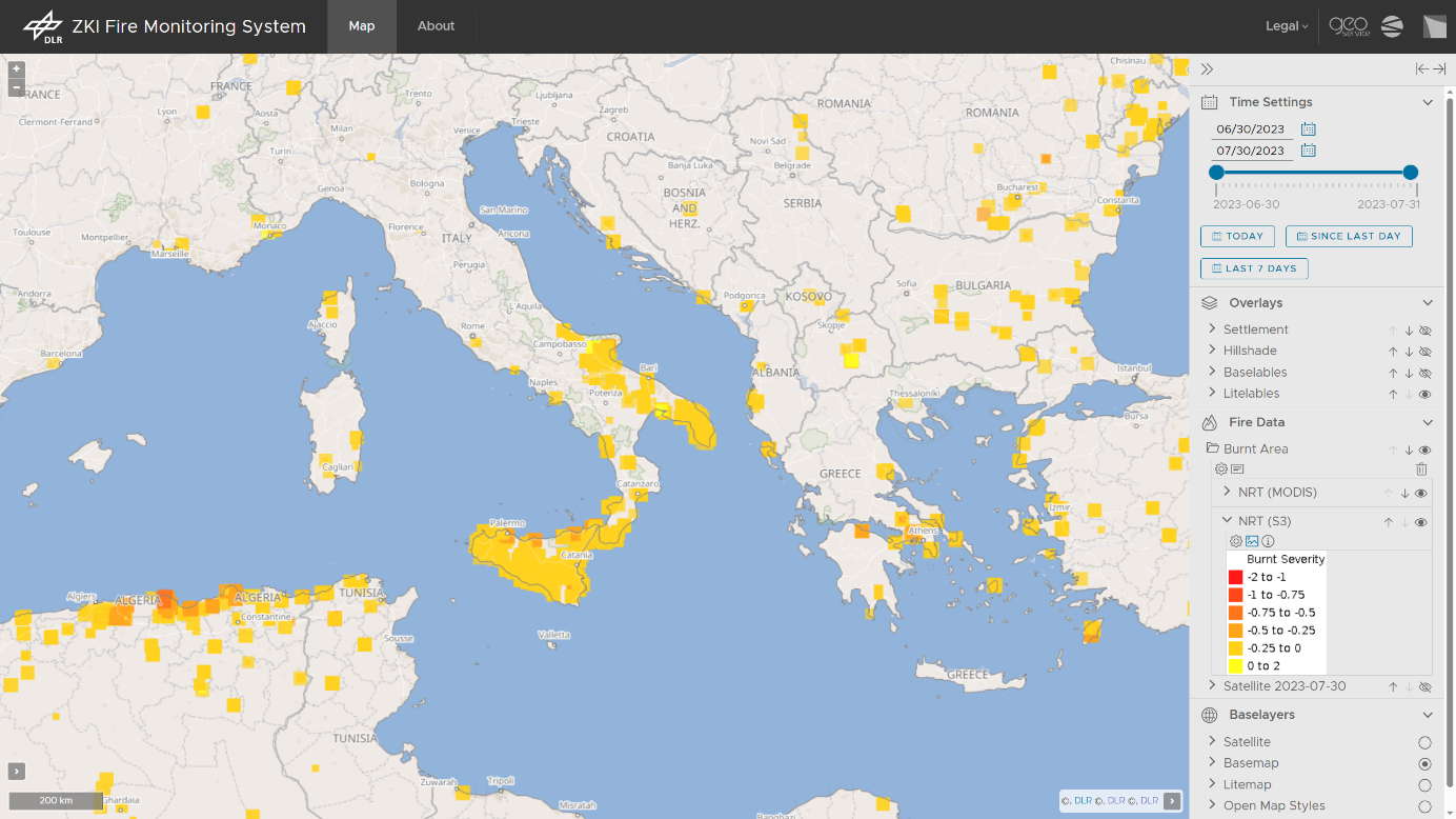
Screenshot of the ZKI Fire Monitoring System.
Credit:
@DLR 2023
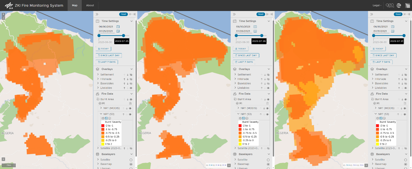
Timeline of the devastating fire in Algeria between 25-31 July 2023, approximately 30km west of the town of Béjaïa.
Credit:
@DLR 2023
The wildfires in the Mediterranean region were exceptionally intense in July 2023, causing devastating damages. According to the European Copernicus Program EFFIS, the burned area is nearly nearly twice as large as the long-term average. A web service provided by the EOC (Earth Observation Center) shows daily updates on the fire's development. Evaluations from the Center for Satellite-based Crisis Information (ZKI) provide information about the extent of the damage, including data from the German hyperspectral satellite EnMAP.
Significant fire events of catastrophic magnitude occurred particularly in Greece, Italy, Tunisia, and Algeria. To assess and compare the environmental impacts, temporal dynamics, and size of such disasters over extended periods of time, researchers at EOC utilize optical satellite images from the European Sentinel satellites 3A and 3B, as well as data from their American counterparts Aqua and Terra. Equipped with instruments for broad-scale observation of land and ocean surfaces, these satellites capture the Earth's surface multiple times daily from altitudes of 700 to 800 kilometers with a ground resolution of 250 to 300 meters. The high temporal frequency of these images allows for filling data gaps. Unlike radar satellites, optical instruments cannot see through smoke columns or clouds. Therefore, the various images are continuously and automatically aligned with each other over several days using a processor developed by the EOC. They are recalculated and reviewed repeatedly to refine the results and close data gaps.
These analyses are consolidated in the ZKI web service at the EOC. There, the development of burned areas over the past days and weeks can be monitored. The upper screenshot displays the web application "ZKI Fire Monitoring System" as of July 31, 2023. It shows all areas with burned areas for the month of July 2023. All results can be obtained through the EOC's geoservice and used for both current situational assessments and multi-year time series analyses. The lower screenshot exemplifies the temporal progression of the devastating fire in Algeria between July 25th and July 31st, 2023, approximately 30 km west of the city of Béjaïa (with around 200,000 inhabitants). In total, an area of more than 15,000 hectares was burned, equivalent to more than 20,000 football fields or twice the size of Lake Chiemsee.
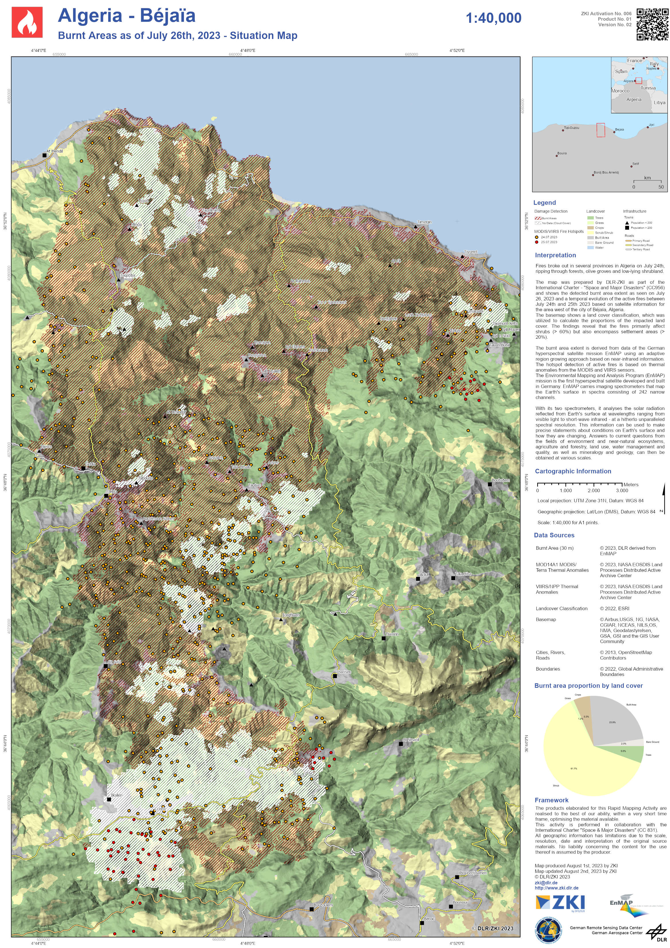
In addition to the broad-scale analyses, the German hyperspectral satellite EnMAP (Environmental Mapping and Analysis Program) observed the damaged area in Algeria in detail on July 26, 2023. With its 224 spectral channels in the wavelength range between 420 and 2450 nanometers and a ground resolution of 30 meters, very accurate analyses are possible. The following map from DLR-ZKI displays the burned areas analysis for the area west of the city of Béjaïa (Algeria), created as part of the "International Charter - Space and Major Disasters." Based on the evaluations, statements about the settlements and roads affected by the fire can be made. The mountainous, forested area along the Mediterranean coast is also used for agriculture and has been repeatedly affected by wildfires in recent years.
Products
Algeria - Béjaïa - Burnt Area - P01-V02 - Burnt Area as of July 26th 2023 - Situation Map