- Startseite
-
About us
-
Crisis Information
- Crisis Information
- Overview
- Mapping and Exercises
- Monitoring Services
-
Services and Projects
-
Latest
- EnglishDeutsch
- Accessibility
- Press
Balkan floods: National Service ZKI-DE activated
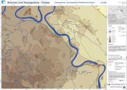
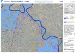
undefinedThe Balkans are enduring the worst floods since records began 120 years ago. In Bosnia and Herzegovina, more than one million people have been affected by the flood disaster. The floods may have dislodged thousands of landmines and contaminated drinking water resources. Several dam breaches have been reported along the Save river at the border of Bosnia and Herzegovina and Croatia. The Federal Agency for Technical Relief (THW) tasked the Center for Satellite Based Crisis Information (ZKI) with the creation of satellite based situational information for an area near the Bosnian City of Orasje.
Products
Bosnia and Herzegowina - Orasje - P02 - Topographic / Hydrographic Reference Map
Creation Date 28. May 2014
Bosnia and Herzegowina - Orasje - P01 - Geographic Reference and Change Analysis May 25/26, 2014
Creation Date 27. May 2014
Further links


